During 2018, we consulted on plans to transform the A647 corridor, to improve bus journey times and reliability, to improve facilities for cyclists and pedestrians, and to tackle congestion. Bus services along the A647 corridor experience daily delays in both the AM and PM peaks due to traffic congestion. Journey times vary significantly from day to day. Over 24,000 bus trips are already made on the Leeds Bradford corridor each day, with nearly 6,000 users in the peak periods. Predicted housing growth and growth in city centre jobs will mean increased travel demand on the corridor which cannot be accommodated by private vehicles without significant worsening of congestion. Journey times and the reliability of journey times is a key constraint on the bus network and makes it difficult to attract new bus users.
In 2016, Connecting Leeds was granted an unprecedented £270 million to invest in the transport network and after two rounds of consultation on the proposals for the A647 corridor, we’re ready to update you on our scheme design. The majority of the responses to the second round of consultation on the proposals for this corridor were positive, with respondents recognising the benefits in improving bus journeys, tackling congestion, and improving facilities for pedestrians and cyclists. We received some valuable feedback from residents and business-owners and incorporated some of this into our plans which you can view below.
Work has now begun to implement these proposals, with construction in the Armley area having started in late October 2020. If you’d like to be kept up to date with our work, please send an email to connectingleeds@leeds.gov.uk
The main elements of the scheme include:
Introducing new bus lanes in key locations where buses are currently impacted by congestion
Reconfiguring the Ledgard Way junction to increase its capacity
Introducing new pedestrian crossings
Improving cycling infrastructure in key locations to build on the existing Cycle Superhighway
Read on to see plans and descriptions section by section. Plans can be downloaded as PDFs from the bottom of the page.
Dawsons Corner to Bramley Town End Roundabout
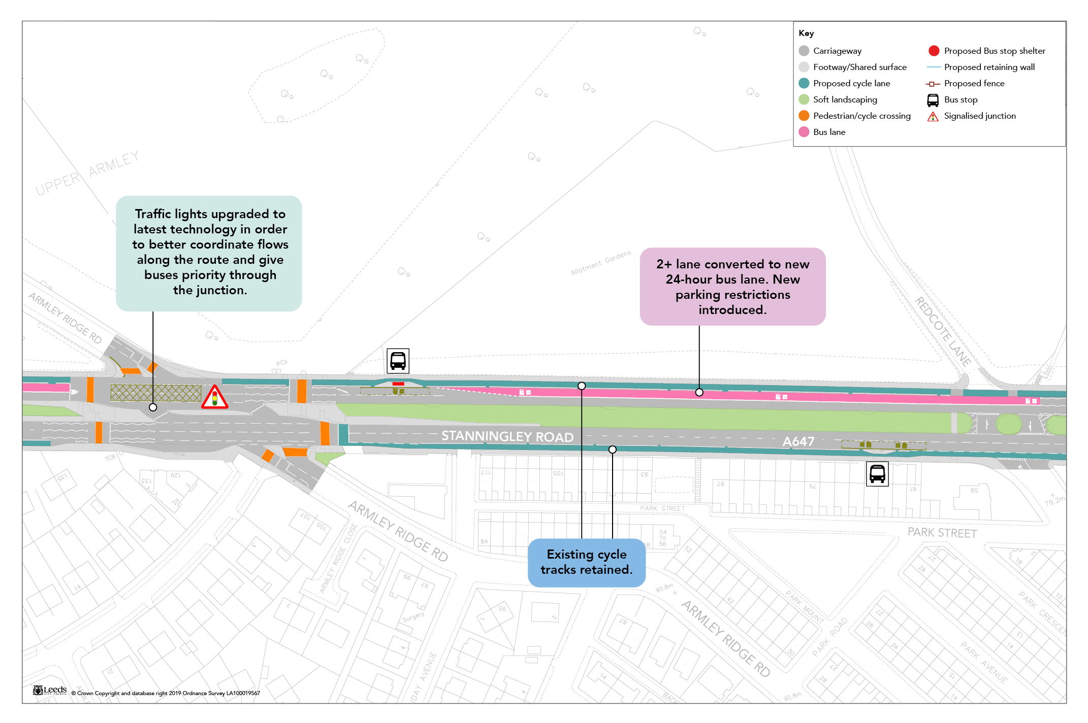
Upgrades to traffic signals at the junctions of Stanningley Road with Swinnow Lane and Swinnow Road to enable buses to be prioritised through these junctions.
The removal of a single parking bay and marking out of two lanes on the approach to the eastbound stop line at the junction of Stanningley Road with Swinnow Road.
An upgrade to the signals at Henconner Lane / Green Hill Road / bypass slip roads to enable reduction of blocking back, and prioritisation of buses.
Plans for this section will be added as soon as they are available. Please keep checking back or sign up for updates.
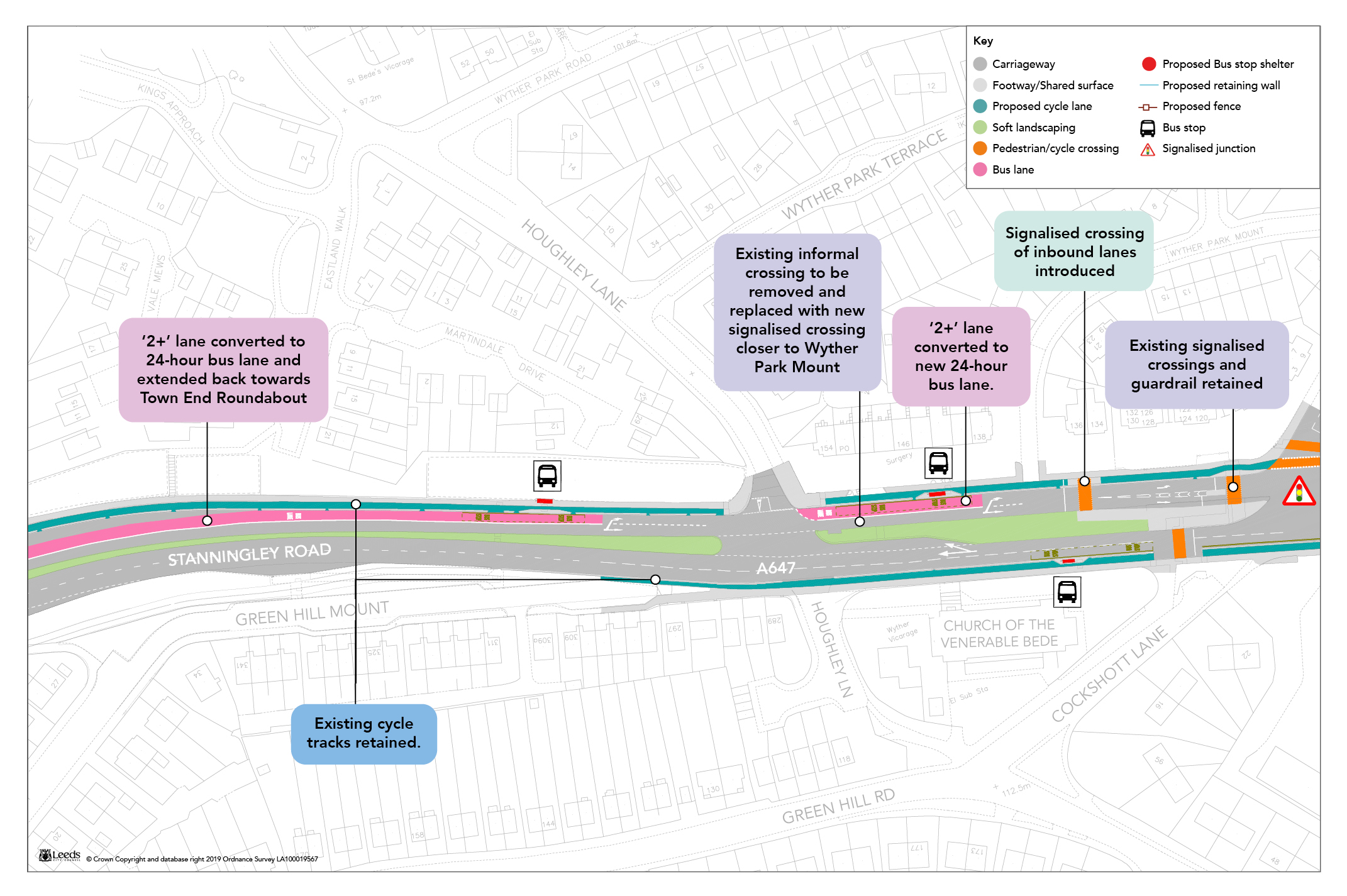
Stanningley Road High Occupancy Vehicle Lane
High Occupancy Vehicle lane (or 2+ lane) on Stanningley Road and Stanningley Bypass to be converted to a bus lane, which will be camera-enforced. This would be 24-hour for the majority of its length, with a section between Cockshott Lane and Armley Ridge Road operating during peak periods only to maintain existing on-street parking for residents in off-peak periods.
Extension of the new bus lane eastwards to a bus gate and new Toucan crossing at the end of the existing dual carriageway section at Pasture Mount.
New bus lane on eastbound slip road connecting Bramley Town End Roundabout to A647 Stanningley Road.
New arrangement at junction with Cockshott Lane, allowing left turners into Cockshott Lane to be signalled separately from straight ahead traffic, to improve capacity and reduce wait times for cyclists.
Permanent ban of the left turn into Armley Ridge Road from Stanningley Road, to improve safety at this junction.
Proposed toucan crossing of the A647 at Redcote Lane (in response to comments received at consultation).
Plan 1: Stanningley Road High Occupancy Vehicle Lane
Plan 2: Stanningley Road High Occupancy Vehicle Lane
Plan 3: Stanningley Road High Occupancy Vehicle Lane
Plan 4: Stanningley Road High Occupancy Vehicle Lane
Plan 5: Stanningley Road High Occupancy Vehicle Lane
Plan 6: Stanningley Road High Occupancy Vehicle Lane
Armley Road
Artists impression of Ledgard Way junction following construction
The scheme will include:
450 metres of outbound bus lane on Armley Road, starting in the vicinity of Abbott Court and finishing 90 metres short of the Ledgard Way junction stop line – this requires 2 metres of widening into allocated greenspace along the majority of the length, with a maximum of 6 metres in the vicinity of the Pickering Street bus stop.
Reduction in the movements allowed at the Ledgard Way junction from 11 to 7, reducing the number of signal stages.
Pickering Street converted to two-way operation at its southern end to facilitate banned movements at Ledgard Way.
New parking restrictions on both sides of Pickering Street, and new loading restrictions on western kerbline, to accommodate increased traffic. Parking provided on one side of Pickering Street for approximately 8 vehicles during off peak periods.
Signalisation of the northern end of Pickering Street to accommodate increased traffic, with signalised pedestrian crossings introduced on each arm of the junction.
New parking and loading restrictions on all approaches to the Pickering Street / Canal Road junctions, to ensure effective flow of traffic through this junction.
Banning of movements into Armley Park Road from Canal Road and Pickering Street, and southern end of Armley Park Road converted to one way southbound, to ensure effective flow of traffic through this junction.
New toucan crossing across Armley Road at Pickering Street.
Closure of the southern end of Canal Road facilitating a better bus stop arrangement and safer cycle route.
Approximately 200 metres of new length of segregated outbound cycle lane either side of the Ledgard Way junction (filling a gap in the current Cycle Superhighway).
Improved pedestrian crossing facilities at the Ledgard Way junction.
Approximately 400 square metres of new footway area around the Ledgard Way junction.
Ledgard Way junction animation
Ledgard Way Junction completion timelapse
Plan 1 Ledgard Way Junction
Plan 2 Armley Road (a)
Plan 3 Armley Road (b)
Plan 4 Armley Road (c)
Plan 5 Pickering Street, Canal Road
The scheme will deliver the following benefits:
Average bus journey time savings on the A647 route of approximately 8 minutes inbound in the AM peak hour, and 7 minutes outbound in the PM peak hour.
Improved bus journey time reliability.
Improved accessibility for pedestrians due to new pedestrian crossings and increased area of footway.
Improved cycle accessibility due to improvements at junctions with Cockshott Lane, Armley Ridge Road and Ledgard Way, and new toucan crossing at Thornbury Barracks.
Reduced journey times for general traffic on the dominant east-west movements, due to the new junction design at Ledgard Way.
The A647 Bus Priority Corridor scheme is expected to finish in summer 2022.


 Armley Road